«Missouri River • Great Plains • Rocky Mountains» | «Radio • Writs • Ride • Resources»
Power Lines en route to Pierre.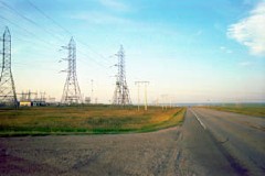
06/25/2001: Pierre, SD |
The Provinces In spite of the lack of services along the way and a stiff headwind, we made good time into pierre. This is, it seems, a town that always plays to sodak's stereotypes: it's only accessible from shoddy, two-lane roads, and its sparse population sprawls across the hilly river bottomland. Economically, you can see the town in decline and how closely aligned with ag-business waning fortunes it really is. Compared to other state capitols in the west, pierre is the veritable provinces. In fact, s. Dakota itself is the veritable provinces... Which is probably why I scurried away from here so quickly when I could. |
«Missouri River • Great Plains • Rocky Mountains» | «Radio • Writs • Ride • Resources»
©2001 Barrett Golding / Josef Verbanac
![]() Funding from the Corporation for Public Broadcasting
Funding from the Corporation for Public Broadcasting