«Missouri River • Great Plains • Rocky Mountains» | «Radio • Writs • Ride • Resources»
Approaching Mobridge from the Southeast.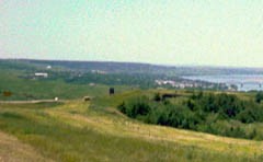
06/26/2001: McLaughlin, SD |
Cheating It was, not to put too fine a point on it, cheating. After struggling with thirty to forty mile an hour winds out of pierre, we met my parents between onida and agar. And tonight we repose in mclaughlin, thirty miles west and over the river, in the heart of the standing rock reservation. This is where I grew up. And I have spent little more than the obligatory times here (holidays, funerals, etc.) Since I left nearly thirteen years ago for more western climes. It is perhaps more than ironic that this is largely where our biking ends... |
«Missouri River • Great Plains • Rocky Mountains» | «Radio • Writs • Ride • Resources»
©2001 Barrett Golding / Josef Verbanac
![]() Funding from the Corporation for Public Broadcasting
Funding from the Corporation for Public Broadcasting